|
Visualization of N-Sensor A-application maps
Sensor Office is an Internet application to visualize N-application data of the N-Sensor. In addition it allows to create maps of the relative biomass distribution of the field.
It is easy to use and no software installation is necessary. The only requirement is the Microsoft Internet Explorer version 5.0 or higher.
Sensor Office – a specialized GIS for N-Sensor data
Sensor Office is a specialized GIS (Geographical information system), which focuses on the main functions required to get a simple N-application and biomass map of the N-Sensor data. Also the inexperienced GIS-user will soon be able to document his N-rates in a professional map. Sensor Office guides you through the software step by step and answers your questions in a comprehensive online help.The processed map can be printed or downloaded as PDF-file.
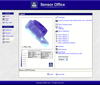 The following functions are available to create a professional map:
- Defining field boundaries: this function allows cutting off tramlines, which are not part of the field to be processed (e.g. drive to the field or a second field logged in the same data file)
- Adjusting the color scale to your data
- Entering or modifying field information to be added on the map
- Adjusting the layout of the map (Display of tramlines or topography of the field…)
For the experienced user Sensor Office offers a data export as comma-separated value files (CSV) in order to further process the data with another GIS. CSV-format is a simple ASCII-text format, which can be read by most of the GIS-software.
You want to testSensor Office?
No problem! Even if you have not worked with the
N-Sensor and do not have own data, just select ‘Start Demo’ right after you started Sensor Office and use one of our demo files.
If you need more information about Sensor Office, please contact
Yara.
|